Tour du Valat
Tour du Valat
  • Navigation access
  • Content access
  • Footer access
  • Adopt a flamingo
  • Documentary portal
  • Search
  • fr
  • en
  • The Tour du Valat
    • History and values
    • The estate
    • Our team
    • Organisation chart and CVs
    • Governance and budget
    • Partners and sponsors
    • Visiting the Tour du Valat
  • Mediterranean wetlands
    • Types of Mediterranean wetlands
    • Threats, issues and protection
    • Spotlight on the Camargue
    • The Mediterranean Alliance for Wetlands
    • The Mediterranean Wetlands Observatory
  • Our actions
  • Media
    • The Library
    • Recent publications
    • Activity reports
    • The HAL portal
    • Books, booklets and reports
    • Institutionnal documents
    • Photo gallery
    • Videos
  • News
  • Support us
    • Adopt a Flamingo
    • Make a contribution
    • Make a donation or bequest
  • Navigation access
  • Content access
  • Footer access
  • Adopt a flamingo
  • Documentary portal
  • Search
  • fr
  • en
Tour du Valat
  • The Tour du Valat
    • History and values
    • The estate
    • Our team
    • Organisation chart and CVs
    • Governance and budget
    • Partners and sponsors
    • Visiting the Tour du Valat
  • Mediterranean wetlands
    • Types of Mediterranean wetlands
    • Threats, issues and protection
    • Spotlight on the Camargue
    • The Mediterranean Alliance for Wetlands
    • The Mediterranean Wetlands Observatory
  • Our actions
  • Media
    • The Library
    • Recent publications
    • Activity reports
    • The HAL portal
    • Books, booklets and reports
    • Institutionnal documents
    • Photo gallery
    • Videos
  • News
  • Support us
    • Adopt a Flamingo
    • Make a contribution
    • Make a donation or bequest
Research institute for the conservation of Mediterranean wetlands
  • Home
  • News
  • Newsletter articles
  • Can mapping help to restore Mediterranean wetlands?
Back to News
  • A- Switch to smaller font size
  • A+ Switch to biggest font size
  • Print
  • Share
  • RSS
Newsletter articles Mediterranean • Published on 11 July 2022

Can mapping help to restore Mediterranean wetlands?

In order to better characterize the health status of Mediterranean wetlands, the changes they are undergoing at large spatial and temporal scales, in order to target the most appropriate conservation and restoration measures, it is often crucial to have high quality mapping data on these environments, providing information on their location, boundaries, habitat types, the main ecosystem services they provide, as well as the threats facing them. Such mapping data, including national wetland inventories, have always been considered by the Ramsar Convention as a key instrument on which to base national policies for the wise use of these ecosystems. Moreover, it is clear that the development and implementation of wetland strategies requires basic knowledge of these areas. The lack of reliable data and information on a country’s wetlands is often one of the major obstacles preventing the implementation of effective conservation, enhancement, and restoration measures.

Earth Observation (EO) data can be used to meet these monitoring needs in an accurate, comprehensive, harmonized, and cost-effective way. For over ten years, the Tour du Valat has been developing real expertise in this field, which it now provides to various institutional and civil society partners in all MedWet countries. This expertise was gained mainly in the ESA GlobWetland-II (2010-2014) and Horizon-2020 Satellite-based Wetlands Observation Service (2015-2019) projects, in which our team participated actively.

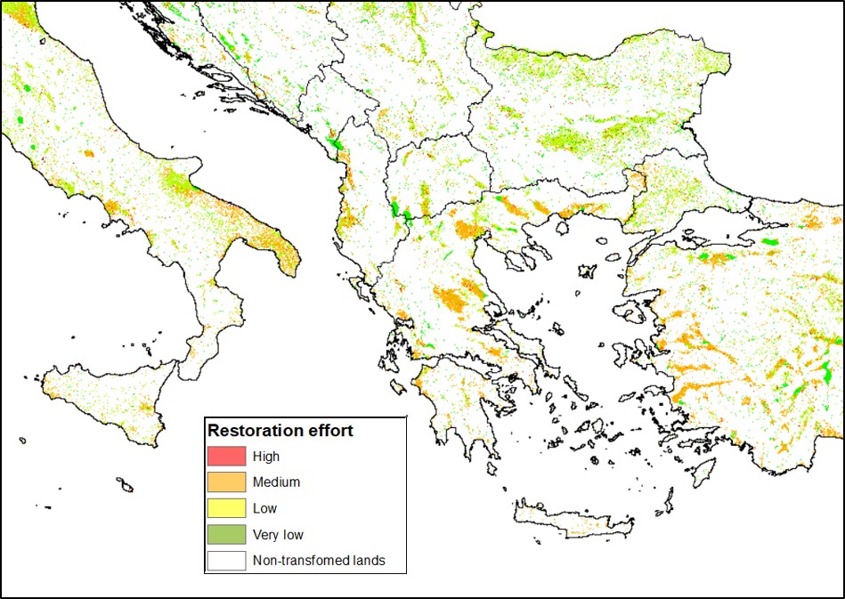
In this context, the Mediterranean Wetlands Observatory (MWO) is developing an innovative mapping approach to better target areas where lost wetland habitats can be recreated and restored. This work is based on large-scale Potential Wetland Mapping (PWM), which uses hydro-ecological data (e.g., topography, surface runoff, geology), combined with climatic variables, on surface water dynamics, in addition to a layer that masks buildings. The result is a pan-Mediterranean map that indicates the probability of the presence of wetland habitats, according to the criteria listed above (Figure 1a et 1b).

Figure 1a. Pan-Mediterranean map of Potential Wetlands


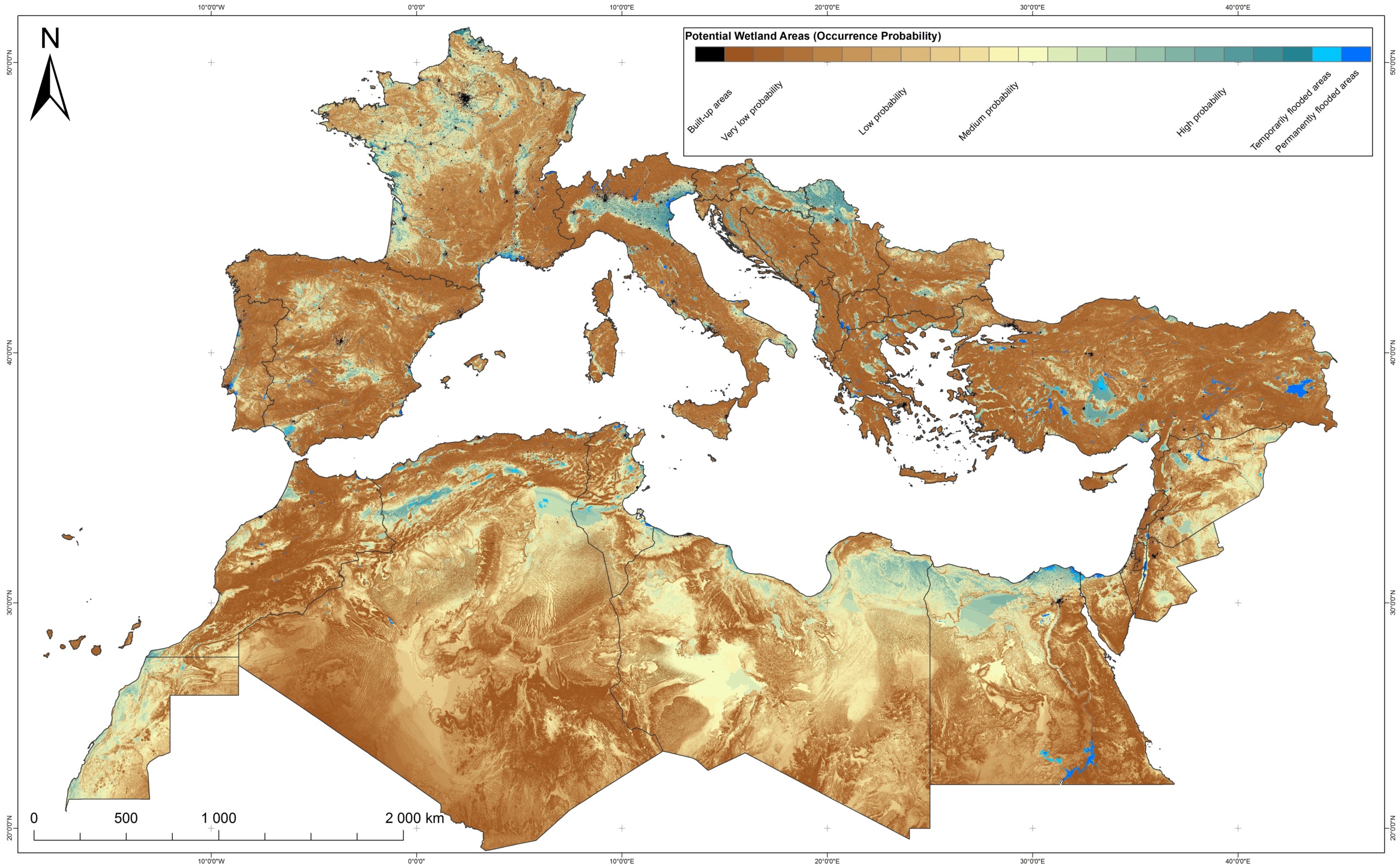
This map could therefore help to locate and delimit former wetlands that have been transformed due to human activities, either drained or converted to other types of land use, such as farming. Therefore, this map of Potential Wetlands could be used as a tool to better prioritize areas for future restoration action.

Figure 1b.close-up of the Aures region and its highland wetlands complex in Algeria


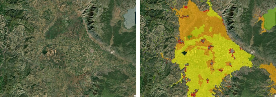
Compared with other spatial data, such as land use and protection status, this Potential Wetlands map would also make it possible to estimate, in a very qualitative way, the effort needed to restore lost wetland habitats. An initial study has been carried out along these lines for the northern part of the Mediterranean Basin and the findings are shown in Figure 2a.

Figure 2a. Map showing lost wetland habitats, with a qualitative estimate of the effort needed to restore them


With this result, we can easily identify some large wetlands that have been completely drained, such as the Maliqi marshes in Albania (Figure 2b), drained and converted to cropland during the 1940s-1950s, mainly for sugar-beet production.


Figure 2b. Close-up of the Maliqi Marshes in Albania


These new data, produced by the MWO, will soon be made available to all Tour du Valat partners and can therefore be used by all stakeholders working for the best management of wetlands in the Mediterranean as a reference base for better locating and prioritising large-scale conservation and restoration efforts (national and/or regional).


Contact : Anis Guelmami (e-mail), project leader – Wetland Dynamics and Water Management Theme


For further

Links

  • Mediterranean Wetland Observatory (MWO)
  • MAPPING AND ASSESSMENT OF THE STATE OF WELAND report 2022
  • SWOS Project (2015-2019)
  • AIonWetlands Project (2022-2024)
  • Advocacy paper (2022)
  • Vidéo (2021) Wetlands: Our best natural answer...
  • Thematic issue on geomatics

Newsletter

Keep up with Tour du Valat news:
Show previous newsletters
News Archives
  • 2025
  • 2024
  • 2023
  • 2022
  • 2021
  • 2020
  • 2019
  • 2018
  • 2017
  • 2016
  • 2015
  • 2014
  • 2013
Agenda Archives
  • 2024
  • 2023
  • 2022
  • 2021
  • 2020
  • 2019
  • 2018
  • 2017
  • 2016
  • 2015
  • 2014
  • 2013

Related
projects

All projects
Completed project

Monitoring water resources in Mediterranean wetlands

Mediterranean • 2011-2020
Completed project

Ecopotential

Camargue, France, Mediterranean • 2015-2019
Ongoing project
Transversal projects

Dragonfly and Damselfly Conservation

Camargue, France • 2014
Ongoing project
Science-Society Interfaces

Conservation status of biodiversity in the Mediterranean Basin

Mediterranean • 2016
Tour du Valat
Tour du Valat

Le Sambuc - 13200 Arles
France

Phone : +33 (0)4 90 97 20 13

[email protected]


Contact
  • Practical information
    • Calendar
    • Past events
    • Vacancies
    • Interactive map
    • Logo & access map
  • Legal information
    • Legal notice
    • Cookie policy (EU)
  • Linkedin
  • Facebook
  • Vimeo
  • RSS
Gérer le consentement aux cookies
We use cookies to enhance your experience on our web site.
Functional Always active
The technical storage or access is strictly necessary for the legitimate purpose of enabling the use of a specific service explicitly requested by the subscriber or user, or for the sole purpose of carrying out the transmission of a communication over an electronic communications network.
Settings
Le stockage ou l’accès technique est nécessaire dans la finalité d’intérêt légitime de stocker des préférences qui ne sont pas demandées par l’abonné ou l’utilisateur.
Statistics
The technical storage or access that is used exclusively for statistical purposes. Le stockage ou l’accès technique qui est utilisé exclusivement dans des finalités statistiques anonymes. En l’absence d’une assignation à comparaître, d’une conformité volontaire de la part de votre fournisseur d’accès à internet ou d’enregistrements supplémentaires provenant d’une tierce partie, les informations stockées ou extraites à cette seule fin ne peuvent généralement pas être utilisées pour vous identifier.
Marketing
The technical storage or access is required to create user profiles to send advertising, or to track the user on a website or across several websites for similar marketing purposes.
Manage options Manage services Manage {vendor_count} vendors Read more about these purposes
See settings
{title} {title} {title}