Tour du Valat
Tour du Valat
  • Navigation access
  • Content access
  • Footer access
  • Adopt a flamingo
  • Documentary portal
  • Search
  • fr
  • en
  • The Tour du Valat
    • History and values
    • The estate
    • Our team
    • Organisation chart and CVs
    • Governance and budget
    • Partners and sponsors
    • Visiting the Tour du Valat
  • Mediterranean wetlands
    • Types of Mediterranean wetlands
    • Threats, issues and protection
    • Spotlight on the Camargue
    • The Mediterranean Alliance for Wetlands
    • The Mediterranean Wetlands Observatory
  • Our actions
  • Media
    • The Library
    • Recent publications
    • Activity reports
    • The HAL portal
    • Books, booklets and reports
    • Institutionnal documents
    • Photo gallery
    • Videos
  • News
  • Support us
    • Adopt a Flamingo
    • Make a contribution
    • Make a donation or bequest
  • Navigation access
  • Content access
  • Footer access
  • Adopt a flamingo
  • Documentary portal
  • Search
  • fr
  • en
Tour du Valat
  • The Tour du Valat
    • History and values
    • The estate
    • Our team
    • Organisation chart and CVs
    • Governance and budget
    • Partners and sponsors
    • Visiting the Tour du Valat
  • Mediterranean wetlands
    • Types of Mediterranean wetlands
    • Threats, issues and protection
    • Spotlight on the Camargue
    • The Mediterranean Alliance for Wetlands
    • The Mediterranean Wetlands Observatory
  • Our actions
  • Media
    • The Library
    • Recent publications
    • Activity reports
    • The HAL portal
    • Books, booklets and reports
    • Institutionnal documents
    • Photo gallery
    • Videos
  • News
  • Support us
    • Adopt a Flamingo
    • Make a contribution
    • Make a donation or bequest
Research institute for the conservation of Mediterranean wetlands
  • Home
  • News
  • Publications
  • New article – Wetland extent tools for SDG 6.6.1 reporting from the Satellite-based Wetland Observation Service (SWOS)
Back to News
  • A- Switch to smaller font size
  • A+ Switch to biggest font size
  • Print
  • Share
  • RSS
Publications Albania, Mediterranean • Published on 29 June 2020

New article – Wetland extent tools for SDG 6.6.1 reporting from the Satellite-based Wetland Observation Service (SWOS)

Anis Guelmami, researcher from the Tour du Valat, recently contributed to a new article published in the journal Remote Sensing of Environment.

It deals with the delimitation and mapping of wetlands using Earth observation tools, particularly to assist countries in their reporting obligations for the SDGs (Sustainable Development Goals). Albania has been chosen here as a Mediterranean case study.

You can find this article on the editor’s website.

Abstract :

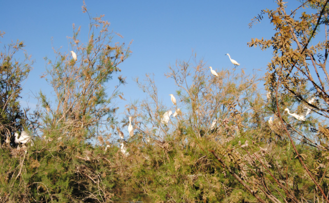
Wetlands are the most fragile and threatened ecosystems worldwide, and also one of the most rapidly declining. At the same time wetlands are typically biodiversity hotspots and provide a range of valuable ecosystem services, such as water supply and purification, disaster risk reduction, climate change adaptation, and carbon sequestration.

Pressures on wetlands are likely to further intensify in the coming decades due to increased global demand for land and water, and due to climate change. Stakeholders at all levels of governance have to be involved to slow, stop and reverse these processes. However, the information they need on wetland extent, their ecological character, and their ecosystem services is often scattered, sparse and difficult to find and access.

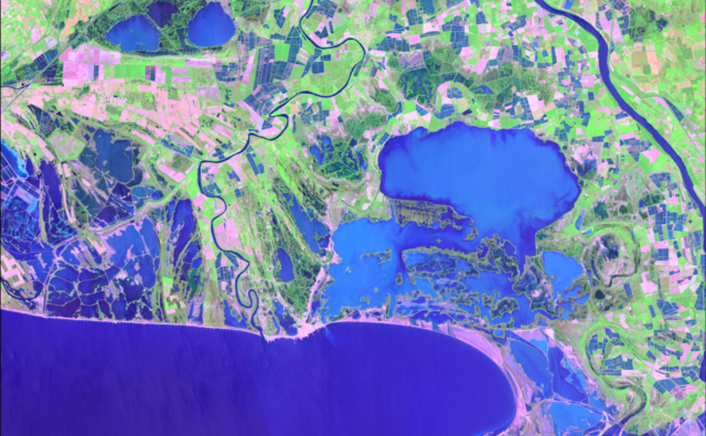
The freely available Sentinel satellite data of the Copernicus Programme, as well as the Landsat archive, provide a comprehensive basis to map and inventory wetland areas (extent), to derive information on the ecological status, as well as long- and short-term trends in wetland characteristics. However, making use of these Earth Observation (EO) resources for robust and standardized wetland monitoring requires expert knowledge on often complex data processing techniques, which impedes practical implementation. In this respect, the Satellite-based Wetland Observation Service (SWOS), a Horizon 2020 funded project (www.swos-service.eu) has developed and made disseminated monitoring approaches based on EO data, specifically designed for less experienced satellite data users.

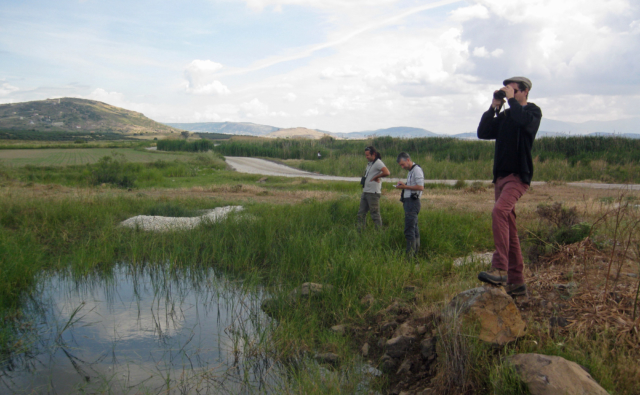
The SWOS monitoring tools aim at assisting countries in conducting national wetland inventories for their Sustainable Development Goals (SDG) reporting and monitoring obligations, and additionally facilitates other monitoring obligations such as those required by the Ramsar Convention and supports decision-making in local conservation activities. The four main components of the SWOS approach are: map and indicator production; software development; capacity building; and initializing the GEO Wetlands Community Portal. Wetland managers and data analysists from more than fifty wetland sites and river basins across Europe, the Middle East, and Africa investigated the benefits and limitations of this EO-based wetland mapping and monitoring approach.

We describe research that applies the SWOS tools to test their potential for the mapping of wetlands in a case study based in Albania, and show its effectiveness to derive metrics relevant to the monitoring of SDG indicator 6.6.1.

Bibliographical reference : Weise K., Höfer R., Franke J., Guelmami A., Simonson W., Muro J. et al. 2020. Wetland extent tools for SDG 6.6.1 reporting from the Satellite-based Wetland Observation Service (SWOS). Remote Sensing of Environment Online:12. DOI : http://dx.doi.org/10.1016/j.rse.2020.111892


Newsletter

Keep up with Tour du Valat news:
Show previous newsletters
News Archives
  • 2025
  • 2024
  • 2023
  • 2022
  • 2021
  • 2020
  • 2019
  • 2018
  • 2017
  • 2016
  • 2015
  • 2014
  • 2013
Agenda Archives
  • 2024
  • 2023
  • 2022
  • 2021
  • 2020
  • 2019
  • 2018
  • 2017
  • 2016
  • 2015
  • 2014
  • 2013

Related
projects

All projects
Ongoing project
Transversal projects

Management and restoration of the Gediz delta, Turkey

Turkey • 2009
Ongoing project
Species Conservation

Participatory project: a study on the migratory behaviour of Eurasian Spoonbills

Camargue, France, Mediterranean
Ongoing project
Science-Society Interfaces

Conservation status of biodiversity in the Mediterranean Basin

Mediterranean • 2016
Completed project

Ecopotential

Camargue, France, Mediterranean • 2015-2019
Tour du Valat
Tour du Valat

Le Sambuc - 13200 Arles
France

Phone : +33 (0)4 90 97 20 13

[email protected]


Contact
  • Practical information
    • Calendar
    • Past events
    • Vacancies
    • Interactive map
    • Logo & access map
  • Legal information
    • Legal notice
    • Cookie policy (EU)
  • Linkedin
  • Facebook
  • Vimeo
  • RSS
Gérer le consentement aux cookies
We use cookies to enhance your experience on our web site.
Functional Always active
The technical storage or access is strictly necessary for the legitimate purpose of enabling the use of a specific service explicitly requested by the subscriber or user, or for the sole purpose of carrying out the transmission of a communication over an electronic communications network.
Settings
Le stockage ou l’accès technique est nécessaire dans la finalité d’intérêt légitime de stocker des préférences qui ne sont pas demandées par l’abonné ou l’utilisateur.
Statistics
The technical storage or access that is used exclusively for statistical purposes. Le stockage ou l’accès technique qui est utilisé exclusivement dans des finalités statistiques anonymes. En l’absence d’une assignation à comparaître, d’une conformité volontaire de la part de votre fournisseur d’accès à internet ou d’enregistrements supplémentaires provenant d’une tierce partie, les informations stockées ou extraites à cette seule fin ne peuvent généralement pas être utilisées pour vous identifier.
Marketing
The technical storage or access is required to create user profiles to send advertising, or to track the user on a website or across several websites for similar marketing purposes.
Manage options Manage services Manage {vendor_count} vendors Read more about these purposes
See settings
{title} {title} {title}