Faced with increasing droughts, recurring floods and accelerating ecosystem degradation, Nature-based Solutions (NbS) are now recognised as essential tools for strengthening the resilience of our areas while preserving and restoring natural environments. However, despite growing interest, scaling them up remains challenging—particularly at the catchment scale: as each catchment has its own specific characteristics, there is still a lack of simple and relevant tools to easily determine which solutions are best suited to local contexts.
In a recent study, an international team including researchers from the Tour du Valat proposed a methodological, practical and reproducible approach for identifying, selecting and mapping the NbS most appropriate for each catchment, with a focus on water resource availability and water management. The aim is to enable local managers and stakeholders to make informed decisions based on both science and the local realities of their regions.
Understanding the cathment to take better action
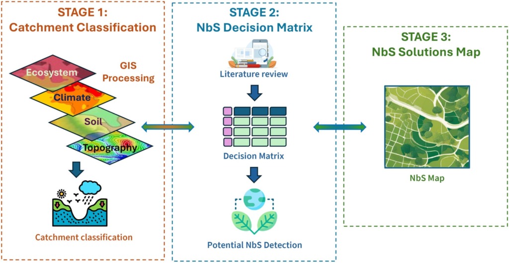
The first step in the methodological approach is to conduct a detailed analysis of the catchment, combining four key dimensions: the dominant ecosystem (agricultural, forest, urban, freshwater, coastal), climate, soil type and topography. Using publicly available data, each sector of the catchment unit is classified according to these characteristics. For example, an area may be identified as ‘agricultural ecosystem – humid climate – permeable soil – mild slope’.
This precise analysis makes it possible to move beyond overly general approaches and identify areas in which certain solutions are not only possible, but also truly relevant.
Matching each context with appropriate solutions
Based on this mapping, the authors conducted a systematic review of international scientific literature to establish a broad catalogue of NbS. Each solution, whether it involved restoring wetlands, reforesting, reconnecting watercourses to their floodplains, planting buffer strips or introducing green infrastructure in towns, was assessed according to its adaptability to the different contexts identified.
The result is a decision-making matrix that links, for each type of territory, the most promising NbS and their co-benefits: improved water quality, carbon sequestration, reduced flood risk, maintenance of biodiversity, leisure services, etc.
For instance, this work shows that sloping agricultural areas with impermeable soils are well suited to terracing or hedgerows, while heavily impermeable urban areas benefit more from green infrastructure, tree planting or infiltration basins.
From theory to practice: the case of the Bode basin in Germany
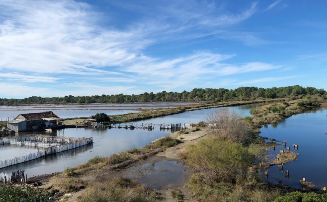
This methodological approach was tested on a 3,300 km² catchment located in central Germany, around the Bode River. This region, characterised by extensive agriculture in the plains, high-altitude forests and artificial watercourses, has suffered severe droughts in the past few years, massive losses of forest cover and deterioration in water quality.
Using the methodology developed, the authors were able to identify the most relevant NbS for each area: green infrastructure and retention basins in urban areas, regenerative agricultural practices and restoration of riparian forests in cultivated plains, reforestation and soil protection in mountainous areas, river restoration and restoration of wetlands in floodplains.
These proposals were then discussed with local experts during a workshop. The discussions led to adjustments in certain priorities, such as reinforcing the importance of NbS aimed at water quality improvement in urban areas or by highlighting the risks associated with the removal of hydraulic structures in sensitive areas.
A tool to strengthen planning and dialogue
The main advantage of this methodology lies in its ability to align scientific data, regional issues and the expectations of local stakeholders. By providing clear and well-substanciated maps, it facilitates consultation, supports public decision-making and helps to target investments on truly useful and sustainable actions.
This tool can be adapted to many contexts, including Mediterranean ones, and is particularly valuable at a time when policy-makers, particularly in Europe, are calling for large-scale ecosystem restoration, improved water management and the development of nature-based adaptation strategies.
In conclusion: a practical tool for the future
This study provides managers, decision-makers and local stakeholders with a practical tool for effectively deploying NbS at the catchment scale. By combining spatial analysis, scientific knowledge and feedback from stakeholders in the field, this approach enables the identification of priority areas for action and the selection of responses that are truly adapted to the context.
It thus provides a clear framework to plan coherent actions, strengthen the resilience of regions to water and climate crises, and direct investments towards measures that are effective, sustainable and beneficial to biodiversity.
Contacts
Anis Guelmani | Project Leader – MWO Coordinator
Michaël Ronse | Project manager – MWO
Publication reference
Sarwar A.N., Caramiello C., Pugliese F., Jomaa S., Guelmami A., Ronse M., Roggero P.P., Marrone N., De Paola F., Cetinkaya I.D., Copty N.K., Rode M., Manfreda S. 2025. A framework for selecting Nature-based Solutions: applications and challenges at the catchment scale. Journal of Environmental Management 394:127220. doi: 10.1016/j.jenvman.2025.127220