The Rhône Delta is a complex socio-ecosystem where water shapes everything: landscapes, biodiversity, human activities, and the ecosystem services on which society depends. Agriculture, natural habitats, and water use constantly interact within a living, ever-evolving system.
Yet, against a backdrop of global change, this delicate balance is now under severe pressure. Anthropogenic factors (water management choices in agricultural and natural areas, crop types) and climatic factors (prolonged droughts, intense rainfall, rising sea levels) directly influence the hydro-salinity balance, a key parameter that influences the dynamics of habitats and species, and of human activities and related ecosystem services.
To better understand these complex interactions, in 2022 the Tour du Valat and INRAE started developing the innovative application MAELIA-Delta. It simulates the relationships between agriculture, water management, biodiversity, and ecosystem services in delta environments, whilst incorporating the central role played by hydro-salinity dynamics.
In addition to being a fundamental research project, this tool is designed to support concrete decision-making. It will enable stakeholders to collectively explore different water management scenarios and assess their consequences, to inform group decisions concerning major challenges such as climate change and rising energy costs.
The Camargue Island: highly diverse landscapes and land uses
In the Camargue, water is everywhere and everything depends on it. Its landscapes, biodiversity, and human activities are closely intertwined in a delicate balance.
This region is a vast mosaic of natural habitats (about 70% lagoons, marshes, salt scrub, grasslands, woodlands) and agricultural areas (about 25% rice farming, market gardening, open range horse and bull farms, and viticulture). This wide range of landscapes, shaped by contrasts in salinity and freshwater availability, makes the Camargue a biodiversity hotspot in France. Many species can be found here, and some with major heritage significance.
The Delta is a vital refuge for a vast number of waterbirds. Throughout the year, it hosts numerous species, including the iconic Greater Flamingo, and one of its largest breeding colonies in the Mediterranean. In winter, the Camargue becomes an important stopover site for cranes, geese, and ducks, as well as for numerous passerines.
This natural biodiversity is protected by a range of areas with different protection statuses: land-based protection (Coastal Protection Agency, Fragile Natural Areas), regulatory protection (National Reserve and Regional Nature Reserves, Regional Nature Park, Natura 2000), and designations (RAMSAR, UNESCO Biosphere Reserve). However, these protected areas are not isolated: they coexist with well-established agricultural activities, predominantly wheat and rice production (in 2023, 68% of all crops (SIT PNRSud 2026)). Increases in market gardening and fodder crops have been observed over the past twenty years; the latter are grown to meet the needs of livestock farming (grazing, hay) and for their roles in helping to improve soil quality (alfalfa) and in crop rotation (rice/wheat) (SIT PNRSud, 2026). Open range livestock farming is also an integral part of the Camargue landscape, contributing to its cultural identity, biodiversity, and appeal to tourists.
A territory shaped by water circulation
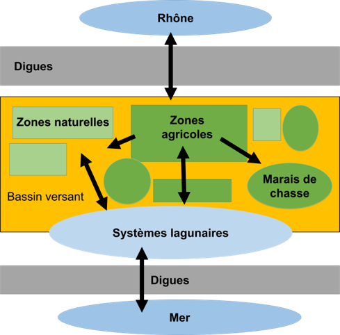
Behind these landscapes, water circulation in the Delta play a key role. The functioning of the Camargue depends not only on rainfall, evaporation, and exchanges with the sea and the groundwater, but also on freshwater drawn from the Rhône, which has been embanked since the 19th century.
This water flows through a complex network of agricultural irrigation and drainage canals. Some of it is pumped back into the Rhône, whilst the rest flows into various systems of ponds and lagoons, affecting their hydro-salinity balance, with consequences on biodiversity and various economic activities (fishing, hunting).
In the Camargue, a large proportion of natural habitats, species, and human activities depend directly on how water is allocated amongst the various ways the land is used. In such an interconnected system, the consequences of changes are often difficult to anticipate. Changes in agricultural practices, a succession of drier years or modifications to canal management can produce cascading effects on soils, lagoons, biodiversity, and human activities. Understanding these interactions across the entire Delta therefore requires a tool capable of simultaneously modelling water, land use, and ecosystems.
MAELIA-Delta: a model to better anticipate the future of the Camargue
How might changes in agriculture, climate, and water management transform the Camargue in the coming years?
To answer this question, the Tour du Valat and INRAE have been developing MAELIA-Delta since 2022. It is a software model that can simulate the dynamics of interactions between water allocation in agricultural catchment areas and natural habitats, agricultural activities, key ecosystem services, and several emblematic species in the region.
In practical terms, this tool enables us to test various scenarios for the region’s future development: changes in agricultural practices, droughts, evolving water management policies, and more. The aim is not to predict the future, but to explore its possibilities. In this way, it will help us to better anticipate the consequences of future changes on the functioning of the entire Delta: both on natural habitats and on the human activities that depend on them.
The simulations focus on several benefits that ecosystems provide to the region:
- provisioning services linked to agriculture, salt production, livestock farming, and fishing;
- water regulation services, with a specific focus on mitigating the risks of drought and salinization;
- cultural services, associated with iconic habitats (such as rice fields) and species (such as the Greater Flamingo), which embody great symbolic value for the region.
 [1]
[1]
From field knowledge to a digital modelTo develop MAELIA-Delta, researchers first sought to identify the key mechanisms that link water, human activities, and biodiversity. In her PhD thesis, Rose Rodier’s [2] extensive analytical work enabled her to identify the interactions between water management, agricultural activities, natural habitats, and certain iconic fish and bird species in the region. This preliminary work was essential for identifying the processes that influence how the Delta functions and which must be incorporated into the model to produce realistic simulations. The aim was to develop a tool that can represent the sometimes-invisible links between the various uses of water and the Camargue’s ecosystems. Using data available at the scale of the Camargue Island, researchers constructed a spatialised digital representation of the area in order to reproduce and analyse the processes highlighted in Rose Rodier’s thesis. |
Adapting an existing tool to the specific characteristics of the Camargue
MAELIA (Multi-agent Modelling of socio-Agro-Ecological systems for Landscape Integrated Assessment) is an assessment and modelling platform designed to represent the spatio-temporal interactions between agricultural activities, water resources, and their management at the catchment basin scale.
The tool is based on a detailed representation of the local territory (agricultural parcels, farms, water networks, natural areas) and on a series of coupled models that can simulate ecological processes as well as the decision-making processes implemented by local stakeholders. It can therefore assess the consequences of different scenarios in terms of socio-economic and environmental impacts, such as water availability, agricultural yields, and soil quality.
However, the Camargue has specific characteristics that had not previously been taken into account in MAELIA. Unlike the catchment areas for which the tool was designed, the Camargue is a deltaic region in which the balance between freshwater and saltwater plays a decisive role. Groundwater upwelling, soil salinization, and the functioning of the Vaccarès lagoon system all have a significant influence on agricultural activities and related ecosystems.
What can MAELIA-Delta already simulate?
Teams at the Tour du Valat and INRAE have been working to adapt MAELIA to these specific conditions since 2022. Several modules have been developed to model rice cultivation and its irrigation practices, the hydro-salinity dynamics specific to deltas, the impact of salt on agricultural yields, and the central role of the Vaccarès lagoon system in water management across the Camargue Island.
Subsequent to the developments carried out by Rose Rodier in her PhD thesis [2], the current version of MAELIA-Delta can be used to simulate the hydro-salinity dynamics of the Vaccarès water system in various contexts: hydraulic infrastructure projects envisaged, the adaptation of management rules for all existing infrastructure, and the visualisation of the consequences of various climate change scenarios (sea-level rise, increased evaporation). These simulations can provide decision-making support for various regional projects, such as the Vaccarès Conservation Plan.
What remains to be done?
Several developments, which will be incorporated into future projects, are still required to achieve the objective of integrated water management modelling at the scale of Camargue Island. These include a more accurate description of how hydraulic canals and natural areas function, the modelling of hunting marshes, and links to the dynamics of plant and animal species.
In a region where every water-related decision can have repercussions for agriculture, the lagoons, biodiversity, and economic activities, having a tool that can explore the consequences of different choices is a major asset. By helping us better understand the interactions that shape the Delta, MAELIA-Delta will help to prepare the Camargue for the challenges it will face in the coming decades.
Bibliography
Béchet A., Rendon-Martos M., Rendon M.A., Amat J.A., Johnson A.R., Gauthier-Clerc M. 2012. Global economy interacts with climate change to jeopardize species conservation: the case of the greater flamingo in the Mediterranean and West Africa. Environmental Conservation 39:1–3.
Boutron, O., Paugam, C., Luna-Laurent, E., Chauvelon, P., Sous, D., Rey, V., Meulé, S., Chérain, Y., Cheiron, A., Migne, E., 2021. Hydro-Saline Dynamics of a Shallow Mediterranean Coastal Lagoon: Complementary Information from Short and Long Term Monitoring. JMSE 9, 701. https://doi.org/10.3390/jmse9070701 [3]
BRL, 2004. Etude hydraulique et hydrobiologique des canaux de Camargue. Volume 1 : Etats des lieux – Diagnostique.
Ernoul L., Wardell-Johnson A., Mathevet R., Sandoz A., Boutron O., Willm L., Arnassant S., Béchet A. 2021. Context in Landscape Planning: Improving Conservation Outcomes by Identifying Social Values for a Flagship Species. Sustainability 13:6827. doi: 10.3390/su13126827 [4]
Galewski T., Devictor V. 2016. When Common Birds Became Rare: Historical Records Shed Light on Long-Term Responses of Bird Communities to Global Change in the Largest Wetland of France. PLOS ONE 11:1–18. doi: 10.1371/journal.pone.0165542 [5]
Gaudou, B., Sibertin-Blanc, C., Therond, O., Amblard, F., Auda, Y., Arcangeli, J.-P., Balestrat, M., Charron-Moirez, M.-H., Gondet, E., Hong, Y., Lardy, R., Louail, T., Mayor, E., Panzoli, D., Sauvage, S., Sánchez-Pérez, J.-M., Taillandier, P., Van Bai, N., Vavasseur, M., Mazzega, P., 2014. The MAELIA Multi-Agent Platform for Integrated Analysis of Interactions Between Agricultural Land-Use and Low-Water Management Strategies, in: Alam, S.J., Parunak, H.V.D. (Eds.), Multi-Agent-Based Simulation XIV, Lecture Notes in Computer Science. Springer Berlin Heidelberg, Berlin, Heidelberg, pp. 85–100. https://doi.org/10.1007/978-3-642-54783-6_6 [6]
McGinnis, M.D., Ostrom, E., 2014. Social-ecological system framework: initial changes and continuing challenges. Ecol. Soc. 19.
Moulin, Aurore. 2024. « Conception d’une représentation numérique et spatialisée pour la modélisation intégrée de l’île de Camargue ». Mémoire de Master, Université de Montpellier / Montpellier SupAgro. 43 pages.
Rodier, 2026. Modélisation intégrée des réseaux d’activités, des services écosystémiques, et de la biodiversité sur l’île de Camargue. Evaluation des impacts du changement climatique et de la transition agroécologique sur un delta. PhD report. Université de Lorraine. 249 pages.
SIT PNRSud , 2026. Système d’Information Territorial des Parcs Naturels Régionaux de Provence-Alpes-Côte d’Azur. « L’occupation du sol en Camargue, état 2023 et son évolution depuis 2001 » https://geo.pnrsud.fr/occupation-du-sol-en-camargue-etat-2016-et-son-evolution-depuis-2001/ [7]
Therond, O., Sibertin-Blanc, C., Lardy, R., Gaudou, B., Balestrat, M., Hong, Y., Louail, T., Nguyen, V.B., Panzoli, D., Sanchez-Pérez, J.-M., Sauvage, S., Taillandier, P., Vavasseur, M., Mazzega, P., 2014. Integrated modelling of social-ecological systems: The MAELIA high-resolution multi-agent platform to deal with water scarcity problems. Presented at the 7th International Environmental Modelling and Software Society (iEMSs 2014), International Environmental Modelling and Software Society, p. 1.
Tremoureux, M., 2019. Impacts de la gestion de l’eau en Camargue sur les services écosystémiques. Rapport de stage de Master 2 Gestion des Eaux et des Milieux Aquatiques, spécialité Zones Humides Méditerranéennes, Université Aix-Marseille, 41p.
Contacts
- Olivier Boutron [8], Tour du Valat : [email protected] [9]
- Arnaud Béchet [10], Tour du Valat : [email protected] [11]
- Olivier Thérond, Laboratoire Agronomie et Environnement, Université de Lorraine, INRAE, France.
- Rose Rodier, Tour du Valat / INRAE.
Funding partners
- BIOSFAIR Metaprogramme [12], INRAE. Funding for Rose Rodier’s PhD scholarship (2022–2026).