Anis Guelmami [1], chercheur de la Tour du Valat, a récemment contribué à un nouvel article publié dans la revue Remote Sensing of Environment.
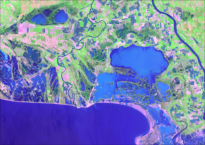
Il traite de la délimitation et de la cartographie des zones humides à l’aide des outils d’observation de la Terre, notamment pour aider les pays dans leurs obligations de rapportage pour les SDGs (Sustainable Development Goals ou Objectifs de Développement Durable). L’Albanie a été choisi ici comme cas d’étude méditerranéen.
Vous pouvez retrouver cet article sur le site de l’éditeur. [2]
Résumé :
Wetlands are the most fragile and threatened ecosystems worldwide, and also one of the most rapidly declining. At the same time wetlands are typically biodiversity hotspots and provide a range of valuable ecosystem services, such as water supply and purification, disaster risk reduction, climate change adaptation, and carbon sequestration.
Pressures on wetlands are likely to further intensify in the coming decades due to increased global demand for land and water, and due to climate change. Stakeholders at all levels of governance have to be involved to slow, stop and reverse these processes. However, the information they need on wetland extent, their ecological character, and their ecosystem services is often scattered, sparse and difficult to find and access.
The freely available Sentinel satellite data of the Copernicus Programme, as well as the Landsat archive, provide a comprehensive basis to map and inventory wetland areas (extent), to derive information on the ecological status, as well as long- and short-term trends in wetland characteristics. However, making use of these Earth Observation (EO) resources for robust and standardized wetland monitoring requires expert knowledge on often complex data processing techniques, which impedes practical implementation. In this respect, the Satellite-based Wetland Observation Service (SWOS), a Horizon 2020 funded project (www.swos-service.eu) has developed and made disseminated monitoring approaches based on EO data, specifically designed for less experienced satellite data users.
The SWOS monitoring tools aim at assisting countries in conducting national wetland inventories for their Sustainable Development Goals (SDG) reporting and monitoring obligations, and additionally facilitates other monitoring obligations such as those required by the Ramsar Convention and supports decision-making in local conservation activities. The four main components of the SWOS approach are: map and indicator production; software development; capacity building; and initializing the GEO Wetlands Community Portal. Wetland managers and data analysists from more than fifty wetland sites and river basins across Europe, the Middle East, and Africa investigated the benefits and limitations of this EO-based wetland mapping and monitoring approach.
We describe research that applies the SWOS tools to test their potential for the mapping of wetlands in a case study based in Albania, and show its effectiveness to derive metrics relevant to the monitoring of SDG indicator 6.6.1.
Référence bibliographique : Weise K., Höfer R., Franke J., Guelmami A., Simonson W., Muro J. et al. 2020. Wetland extent tools for SDG 6.6.1 reporting from the Satellite-based Wetland Observation Service (SWOS). Remote Sensing of Environment Online:12. DOI : http://dx.doi.org/10.1016/j.rse.2020.111892