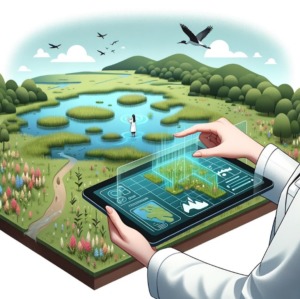
 Numerical modelling based on observation data enables the Tour du Valat and its partners to explore various future scenarios. Several tools are currently being developed to provide better support for our wetland restoration and management programmes. For example, numerical modelling can be used to anticipate the consequences of the actions we implement, by taking better account of parameters such as the impact of storms on the coast, the ecological status of lagoons, and the interactions between networks of activities, ecosystem services, and biodiversity.
Mediterranean wetlands are among the most highly threatened ecosystems in the world, with degradation resulting from artificialisation, land use changes, and pollution. All these factors have led to the disappearance of more than 48% of these ecosystems since 1970, despite the fact that they provide our societies essential services such as CO₂ storage, water purification, and biological production. The aim of wetland restoration policies is to halt and reverse these degradation processes, which will result in improved ecosystem services and a restoration of biodiversity [1]. [1]
Wetland restoration and management programmes are linked to long-term actions and objectives. In the current context of global changes, these programmes must be considered in terms of the future environment, in order put in place “adaptive” approaches [2] [2]. To target their actions more effectively, managers need to estimate the extent of the consequences of these changes and how quickly they will occur. Modelling is a tool that can provide answers to these future objectives and support such programmes. That is why the Tour du Valat, as a site manager in charge of restoration projects (for example, the ponds and marshes on the Camargue saltworks site), or as an expert supporting the managers of other sites (the Narbonnais lagunes, the Camargue National Nature Reserve), applies prospective approaches, based on modelling, to wetlands.
In the broad field of environmental sciences, a numerical model is defined as a tool that formalises and transcribes the laws and relationships of a biological, physico-chemical, or mechanical system. It incorporates variables, i.e., a set of elements considered explanatory, which will also define the use that will be made of the model. Therefore, in essence, a model can be used to simplify and reproduce a system that has complex interactions. To simplify or reproduce processes, it is necessary to understand the system to be modelled. This is why it is necessary to have observational data before implementing modelling approaches, which will be even richer for a site with mature, long-term monitoring. These data can be used to achieve two necessary phases: calibration (making model variables match observations) and validation (comparing model results to a test case). Once the model is calibrated and validated, the uncertainties are quantified and the limitations are known. Then, this approach can be used to look ahead, and the model variables can be transposed to future scenarios.
The construction and use of a model for wetland restoration and management projects allows testing and predicting the effects of outside interventions as well as those of natural dynamics on a site virtually. Optimizing the natural, human, and financial resources required to implement the intervention that fits the best. For these restoration and management scenarios, we must consider the IPCC’s climate change projections. In this way, variables such as rainfall, temperature, and sea-level rise can be modulated to correspond to the projections calculated for 2050 or 2100, which makes it possible to model their impact for different restoration and management scenarios.
For the Tour du Valat’s activities, various modelling tools are used to support wetland restoration and management programmes from the Rhone Delta to the Mediterranean Basin, across a wide range of themes, scales, and territories. Their aim is to provide results that will shed light on the future and the possibilities for restoring and managing these study sites.
Three modelling approaches developed at the Tour du Valat
Hydraulic and morpho-dynamic modelling applied to the former Camargue salt works site
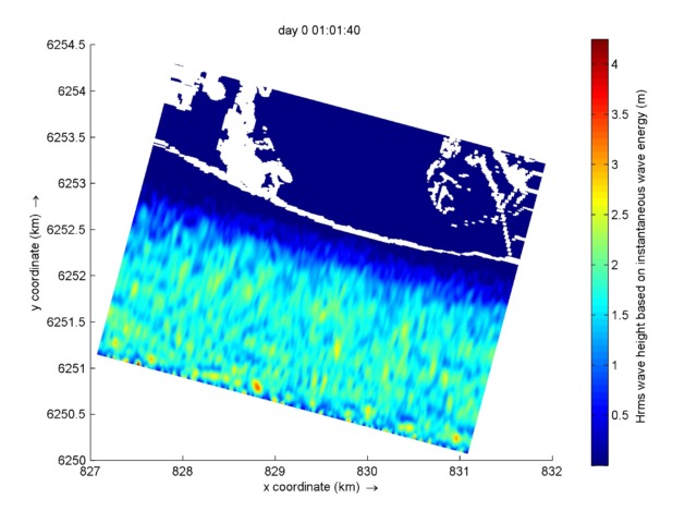
Using forward-looking models to target water management and anticipate the consequences of storm events on the coast.
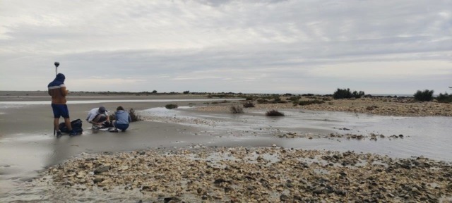
The Étangs et Marais des Salins de Camargue site (former Camargue salt works) is in the Rhone Delta, in the middle of the Camargue Regional Nature Park. Once used for salt production, this site is now owned by the Conservatoire du Littoral (French coastal protection agency) and co-managed by the Camargue Regional Natural Park (coordinating manager), the Tour du Valat, and the National Nature Protection Society (SNPN). A habitat restoration project was launched in 2011 [3]and is continuing today with the establishment of a 2023-2032 management plan and the site participating in the European H2020 Rest-Coast project. [4] The main aim of this restoration is to encourage plant and animal species to recolonise the area by re-establishing the natural dynamics of the site’s hydrological processes. Using the TELEMAC 2D [5] model, which models surface water runoff and salinity for different types of environments, it was possible to define the impact of the restoration measures implemented on the site’s hydro-salininity dynamics. The tool also makes it possible to target the water management required to meet environmental quality expectations, particularly in terms of Water Framework Directive assessment indicators. To achieve this objective, a large network of hydraulic sensors (water level, temperature, salinity) has been installed in the lagoons over the last ten years, and it provides the model with data.
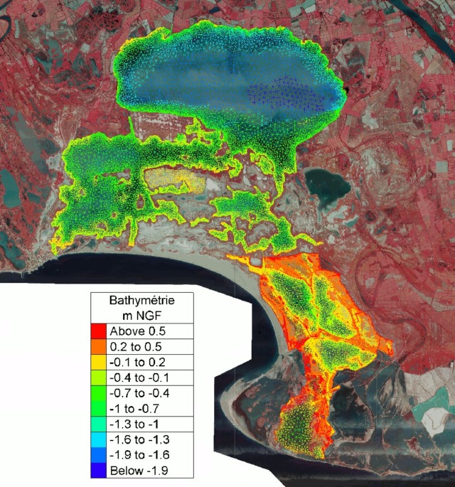
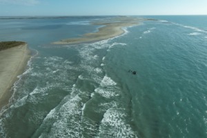
On this site, an adaptive management strategy for the coastal strip is also being applied, with the decision to no longer maintain the historic dykes of the salt production site, in the immediate vicinity of the sea, which will lead to their gradual erosion. Protection against the risk of marine submersion is provided by a seawall, located 4 to 5 km from the coast, which must be reinforced and restored to its initial condition where it has been damaged, as part of the coastal strategy that will soon be defined for the Rhone Delta. Natural morpho-dynamic processes are being re-established locally (new connections with the sea, formation of beach areas). This process is leading to the emergence of a natural buffer zone that will enable us to cope better with the consequences of climate change such as marine submersion and increasing salinisation. The X-beach model [6] is being used to understand and anticipate the action of marine conditions during storms (waves, currents, water level) and their impact on the morphology of this rapidly changing coastline. To provide data for this model, a statistical study has been carried out to characterise storms and their return periods, both historically and in terms of the impact of climate change. Seasonal topographical monitoring has been carried out and fed into the modelling software. Various management scenarios will be tested, ranging from the maintenance of dykes to their gradual removal or dismantlement.
The aim of an integrated approach is to combine the results of these two models. This method will provide long-term trends on the complex synergy between the dynamics of the coastal strip and the lagoons, whose reconnection and exchanges are encouraged by this restoration project.
Modelling nitrogen and phosphorous fluxes that allow the good functioning of the lagoon ecosystem in the French Mediterranean coast
Improving management of the ecological status and water quality in French mediterranean lagoons
Nitrogen and phosphorus are essential nutrients for the growth, development, and reproduction of plants, algae, and phytoplankton. Yet, nitrogen and phosphorus concentrations have increased since the 1960s, mainly due to three anthropogenic causes: (i) the use of nitrogenous fertilisers for intensive agriculture and livestock farming, (ii) the purification capacities of wastewater treatment systems, which are insufficient given the increasing population, and (iii) deforestation and changes in the use of alluvial plains, for agricultural land or urban areas, which results in contaminated rainwater runoff and hinders water infiltration into the soil.
The increase in nutrients, also known as eutrophication, leads to algal blooms, the loss of species of economic or heritage interest, and the presence of invasive species. However, if this phenomenon is detected in time, it can be reversed. The lagoons along the French coast are currently facing considerable pressure from human activity. In some lagoons, efforts have been made to restore water quality or reduce its degradation of aquatic ecosystems and their biodiversity. Nevertheless, many lagoons are still in a degraded state.
In this context, Admissible Nutrient Flows mission for lagoons has been developed within the framework of the Master Plan for Water Development and Management for the Rhone Mediterranean Corsica Basin – Schéma Directeur d’Aménagement et de Gestion des Eaux (SDAGE) and adapted in most of the Water Development and Management Plans – Schémas d’Aménagement et de Gestion des Eaux (SAGE) linked to lagoon territories.
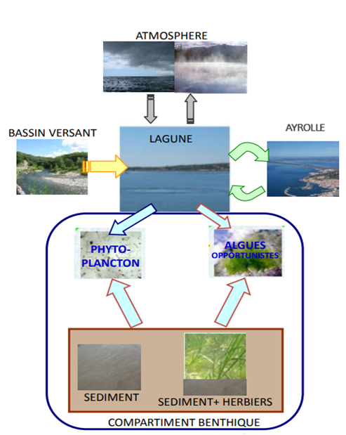
The Water Agency, Ifremer, and the Tour du Valat are in charge to support and assist managers who wish to engage in the Admissible Nutrient Flows mission that targets lagoons in degraded ecological condition. The mission aims to understand the nitrogen and phosphorus flows compatible with the good ecological functionality of each specific lagoon. To achieve that, we use a management tool for eutrophicated lagoon environments (GAMELag) [7], developed within a partnership between Ifremer and the Rhone-Mediterranean and Corsica Water Agency. GAMELag is a model that simulates the main hydrological and biogeochemical processes linked to eutrophication in lagoon environments. This model is based on a simplified representation of the lagoon as box that exchange water and matter with three other boxes (catchment area, the sea, and the atmosphere). In the lagoon-box, the model simulates the temporal evolution of the quantities of nitrogen and phosphorus available in the water column, and stocked on the phytoplankton, zooplankton, macrophytes and sediments according to the flows of nutrients brought in by the catchment areas and exchanged (exported and imported) with the atmosphere and the sea. These simulated dynamics are evaluated in comparison with in situ observations to verify that the model can accurately account for the lagoon’s ecological dynamics.
Once the model has been validated, the “reference state” is established, and it is the starting point for creating virtual restoration scenarios. The scenarios are discussed and drawn up by local stakeholders, incorporating their priorities and needs. These scenarios are used to assess the impact of management actions on the ecological functioning of the lagoon. Through this process, managers can comprehend, and discuss about different options before implementing them. This will significantly optimize the costs reduce conflicts, and has the scientific basis to prove that these actions will improve the ecological status of the lagoon.
Since its launch in 2022, this mission has been implemented in the Campignol Lagoon in the Aude Department and the Scamandre Crey Charnier lagoon complex in the Gard Department. Next year it will be rolled out in the Vendres Lagoon and the Palavasiens lagoons in the Hérault Department, and the Vaccarès Lagoon in the Bouches de Rhône Department.
Integrated water management in the Rhone Delta based on integrated modelling of activity networks, ecosystem services, and biodiversity
Facilitating decision-making in the Ile de Camargue area by modelling the interactions between the different ecological factors there.
The Ile de Camargue, located between the two branches of the Rhone, is a complex socio-economic system with major challenges in terms of biodiversity as well as economic and cultural activities. The circulation of fresh and salt water in this delta is influenced by anthropogenic and climatic factors, which have been accentuated by global changes, and affect human activities, biodiversity, and the associated ecosystem services. In response to a lack of knowledge about the effects of these stressors on the Ile de Camargue area, a model has been developed to simulate the dynamics of the relationships between climate, agricultural activities, water resource management, ecosystem services, and biodiversity. To model this system, the MAELIA model (Modelling of socio-Agro-Ecological systems for Landscape Integrated Assessment) [8] will be adapted to the specific characteristics of the Rhone Delta (its hydrosalinity dynamics and their impacts on biodiversity). MAELIA is a multi-agent platform for the integrated modelling and assessment of agricultural areas, which are conceptualised as socio-agro-ecological systems. The aim of this modelling project is to provide the foundations for the integrated modelling of the Rhone Delta, including its activity networks, ecosystem services, and biodiversity, focusing initially on the Ile de Camargue. This model will meet the needs of local stakeholders by providing a decision-making tool that will help management bodies take account of these issues. This work is being carried out within the scope of a thesis co-supervised by INRAE’s Agronomy and Environment Laboratory and Tour du Valat (BIOSEFAIR meta-programme “Promoting biodiversity and strengthening ecosystem service networks”). It should provide all the stakeholders in the Ile de Camargue area with an integrated water management tool that takes account of the many ecological and economic issues involved.
Conclusion: Applications and limitations of numerical models
Models are often tools derived directly from scientific research, requiring substantial computing resources, large datasets, and detailed thematic knowledge if they are to be successfully implemented. While their contribution to understanding our environment and its systemic relationships helps us make progress in many fields, understanding the limits of a model, which remains limited due to its simplification, is a point that should not be ignored. It is therefore important to take these factors into account, to clearly define the objectives to be met by the model and ensure that the approach will be successful.
Although these tools are now moving beyond the realm of academic research to help managers, it is important to realise that their results can be used to produce trends, the level of detail or accuracy of which depends on the complexity of the system and the variables involved.
The use of modelling tools at the Tour du Valat has demonstrated the need to combine observation and modelling approaches, in order to achieve the most realistic possible view of the questions being studied. Significant advances in observation techniques, particularly spatial and cartographic ones[3] [9] have made it possible to improve the accuracy and quantity of variables, and therefore the final accuracy of the models.
[1] [10]https://tourduvalat.org/en/actualites-en/restauration-des-zones-humides-mediterraneennes-le-nouveau-manuel-du-decideur-pour-la-gestion-durable-et-la-restauration-des-ecosystemes-dici-2030/https://tourduvalat.org/dossier-newsletter/la-restauration-des-anciens-salins-de-camargue-une-solution-fondee-sur-la-nature-pour-sadapter-a-lelevation-du-niveau-marin/ [11]
[2] [12]https://tourduvalat.org/en/newsletter-articles/the-restoration-of-the-former-saltworks-in-the-camargue-a-nature-based-solution-to-adapt-to-sea-level-rise/https://tourduvalat.org/dossier-newsletter/la-restauration-des-anciens-salins-de-camargue-une-solution-fondee-sur-la-nature-pour-sadapter-a-lelevation-du-niveau-marin/ [13]
[3] [14]https://tourduvalat.org/en/newsletter-articles/la-cartographie-au-service-de-la-restauration-des-zones-humides-mediterraneennes/https://tourduvalat.org/dossier-newsletter/la-cartographie-au-service-de-la-restauration-des-zones-humides-mediterraneennes/ [15]
Contact : Morgane Jolivet [16], Project leader – Coastal morphodynamics and climate change and Columba Martinez-Espinosa [17], Research engineer