A longlasting involvement
The Tour du Valat started working in the field of geomatics in the early 1990s.
At that time, our aim was to inventory wetland habitats based on spatially referenced information that could be used for all countries in the Mediterranean Basin. Our principal fields of study were passive satellite remote sensing (visible, near-infrared, and mid-infrared) and active satellite remote sensing (radar), digital topography, and geographic information systems (GIS), which are among the key tools used in geomatics. The first such software tools were developed for military purposes and scientific research in the late 1960s.
The rapid development of remote sensing, stemming from the democratisation of computers combined with the arrival of satellite data, is one of the reasons behind the development of geomatics. The first civilian satellite images were acquired in 1972 by the satellite Landsat 1, and in 1999 the launch of the satellite Ikonos enabled the first metric resolution images to be captured.
Geomatics (a neologism created in the late 1980s by combining the words “geography” and “informatics”) emerged when it became possible to compile various sources of digital geographic data, most of which were derived from the processing of satellite images, but also from other sources such as digital cartography and topography.
The Tour du Valat has initiated or supported the use of geomatics in many projects. Several current and future projects (will) use satellite remote sensing to inventory and monitor wetlands.
Current use of geomatics for wetlands research
Because of the significant progress made in the field of geomatics, it can now be used in many ways to improve our knowledge of wetlands conservation and their catchment areas at various scales.
The RhoMéO programme
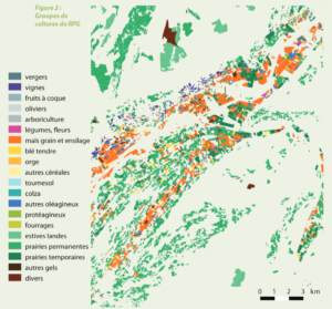
The RhoMéO programme, which was funded by the Rhone-Mediterranean-Corsican water agency from 2009 to 2013, and brought together 30 organisations in the Rhone-Mediterranean basin, is a concrete example of how the Tour du Valat has used geomatics in its research. The various organisations involved mobilised their expertise to design and test out different indicators at some 200 sites, in view of setting up a wetlands observatory.

Land use mapping by crop variety in one of the 200 Rhomeo project sites (high resolution version here opposite)
The outcome of this work is a toolbox for monitoring wetlands in the Rhone-Mediterranean Basin, intended for stakeholders and managers who would like to set up monitoring protocol for assessing the conservation status of wetlands and the pressures they face.
Of the 13 indicators selected, those requiring a spatial approach and the use of geomatic techniques were developed by the Tour du Valat (the level of agricultural pressure and the level of urban pressure).
In the framework of this project, the Tour du Valat has also participated in an exploratory testing phase on the possibility of using earth observation tools, such as satellite images, to develop spatial indicators for monitoring wetlands (mapping the extent of wetlands, of flooding within these areas, and land cover changes).
All of these results have enabled us to improve our knowledge of how to use remote sensing to monitor the condition of wetlands, and better define the spatial indicators used by the Mediterranean Wetlands Observatory, which is based at the Tour du Valat.
The Globwetland 2 project
The MWO also conducted a study on land cover changes in coastal Mediterranean wetlands from 1975 to 2005, which was based on a system developed by the GlobWetland-II (GW-II) project.
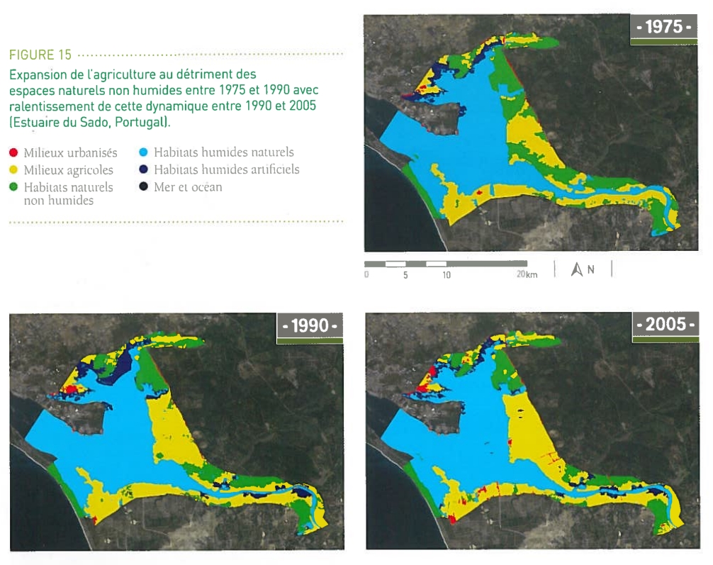
Exemple of a Globwetland 2 project cartography, related to the land use dynamics between 1975, 1990 and 2005 in the Sado estuary (Portugal) (high resolution version here opposite)
GW-II was launched in 2010 by the European Space Agency (ESA), and until 2014, it entailed a regional pilot project aimed at facilitating the use of earth observation techniques in the management and conservation of Mediterranean wetland habitats. Its principal objective was to help put in place a Global Wetlands Observing System (G-WOS) in line with the Ramsar Convention strategic plan for wetlands.
The MWO developed a monitoring and evaluation system, based on mapping land cover and the study of how it changed from 1975 to 2005, which is in harmony with European land cover monitoring (Corine Land Cover). Then a group of 284 sites was selected in the southern and eastern parts of the Mediterranean Basin (from Morocco to Syria) as well as in the northern part (from Turkey to Portugal), before the spatial indicators that provide information on the surface area of the different habitats in them could be calculated.
The maps of 214 coastal wetlands in 22 Mediterranean countries, along with the indicators associated with them, were then analysed. This work enabled us to complete the first such 30-year study on land cover change in wetlands. It is based on mapping data at the scale of the Mediterranean Basin, and shows a decline in natural wetland habitats from 1975 to 2005 of about 10%, and an increase in artificial wetland habitats.
Geomatics used for counting waterbirds in the Sudan (in cooperation with ONCFS)
While these two projects have enabled the Tour du Valat to develop its expertise in extracting and analysing spatial data for flooded areas, the data obtained from the satellite images processed can now be compared with field data.
For instance, in the long term, the mapping of flooded areas at the scale of a country in the Sahel (Sudan), will enable the most important wetlands for waterbird populations to be identified.
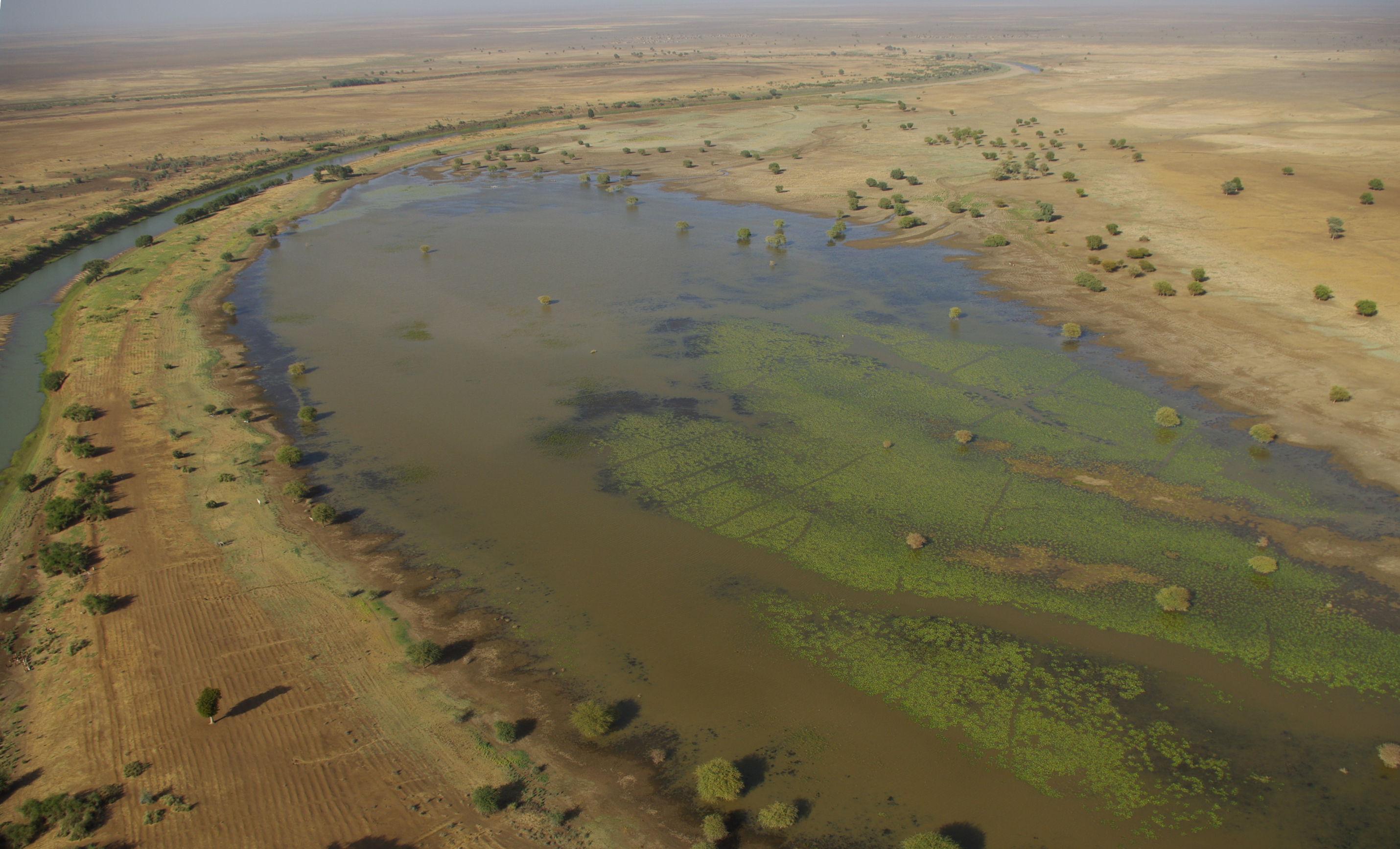
Temporary wetland in the Blue Nile flood plain, Sudan (photo credit ONCFS 2014)
The flooded areas were extracted from Landsat 8 satellite images, used during the field monitoring operations carried out by the ONCFS (National Office for Hunting and Wildlife) over the past four years. Once this spatial data gathering system has been made more robust by combining it with other data, such as point counts, vegetation index and topography, it may facilitate the in-situ identification and monitoring of temporarily flooded areas.
This first such study should improve our knowledge of areas that are flooded during the winter (dry period) in this huge country with zones difficult to access, and in the long term update our knowledge of the importance of this country for waterbirds in terms of their flyway. Wetlands are indeed an important resource for local communities, and essential natural habitats for migratory species.
Future Tour du Valat projects involving geomatics
The Tour du Valat has more than 20 years of experience in the field of geomatics, and will continue working on similar projects.
The SWOS project (2015 – 2018)
One example is the SWOS project (Satellite-based Wetland Observation System), which is funded by the European Union’s Horizon-2020 programme for research and innovation, and brings together a consortium of 12 partners (including the Tour du Valat) from seven European countries.
Its aim is to create a wetlands observation and monitoring system based on the use of satellite images within the framework of the EU biodiversity strategy. The products resulting from the SWOS project may then be integrated into the MAES (Mapping and Assessment of Ecosystem Services) project, through the development of indicators relating to the ecological services provided by wetlands.
Different types of cartographic products will be made with the satellite data acquired within the framework of this project, principally at two geographic scales: site scale (land cover maps, land cover changes, and water quality), and catchment area scale (inventory of wetland habitats, and mapping of flooding dynamics, humidity, and surface temperature).

Cartography exemple of the SWOS project (high resolution version here opposite)
On the basis of these maps, the Tour du Valat will be in charge of developing spatial indicators that can provide information on the status and changes in wetland ecosystems and their ecological services. These indicators will be developed using the results obtained within the framework of other similar projects, such as GlobWetland-II and RhoMéO. However, the added value of the SWOS project compared to the other two projects will be the integration of completely new cartographic products.
As soon as the project begins in 2015, the potential users will be identified near the selected test sites at different scales. They will then be contacted during all the different project development phases, in order to offer them the services and tools that best meet their needs. These tools should help them in their management and conservation work, and will be useful for them in terms of honouring certain commitments relating to the protection of natural habitats including wetlands (national Ramsar reports, Natura 2000 site monitoring, Water Framework Directive, Habitats Directive , etc.)
All of the tools, services, and products made within the SWOS project will be available on line via a website created at the end of the project where they will be placed in order to facilitate their distribution and transfer. The SWOS project will also contribute to the development of the Ramsar Convention Global Wetland Observing System.
H2020 Ecopotential
Ecopotential is another European research project funded within the framework of the Horizon-2020 programme, and the Tour du Valat will be greatly involved in its geomatics part in the upcoming years.
Managed by the Italian National Research Centre, its goal is to create a standard framework for studying ecosystems and related services, and for managing protected areas in Europe, including the Camargue.
The data acquired through remote sensing will be combined with field data to model the functioning of ecosystems and how they provide ecological services, before scenarios are developed to determine future needs in terms of protected areas.
Here again open access will be given to all data and knowledge, via a virtual platform integrated into the GEOSS (Global Earth Observation System of Systems) programme.
Inventory of wetlands in the Mediterranean Basin
In the near future, in a partnership with the MedWet Initiative, the Tour du Valat is planning to map all the flooded areas in the Mediterranean Basin, which will be combined with monitoring and ultimately integrated into a GIS, to create a true knowledge base of Mediterranean wetlands.
What are the prospects for geomatics in the near future?
Geomatics is now principally based on the use of satellite images, and in the near future, it will be able to benefit from new high quality data provided by various programmes.
For example, the Sentinel-2 satellites put in orbit in the framework of the EU Copernicus programme, such as Sentinel-2A, launched in June 2015, will produce high-resolution global imagery, and its counterpart Sentinel-2B will be launched in 2016. The types of images they will provide can be used within projects such as SWOS, to complement the radar images made by the Sentinel-1 satellite.
Images from Sentinel-2A will also be made available as of December 2015 within the framework of THEIA, an organisation with many partners (CEA, CIRAD, CNES, IGN, INRA, CNRS, IRD, Irstea, and Météo France), which aims to meet the needs of the scientific community in terms of products, methods, and training linked to the observation of continental surfaces from space. Its objective is to facilitate the access to and use of high and very high resolution spatial data for a wide range of users.